Last updated: June 2020
Walk Map | Download walk as PDF
I love walks with ups and downs, twists and turns and hidden nooks and crannies, which is one of the reasons that urban walks appeal to me. However, sometimes what I need is just big sky, fresh air and lots of it. I also feel a powerful connection with the coast. This is why I like to walk at Severn Beach.
This walk along the sea defences at Severn Beach can sometimes seem bleak; others might even call it featureless, although I would respectfully disagree.
Severn Beach experienced a brief heyday as a seaside pleasure destination in the golden age of rail, before car travel to more remote places was commonplace. 1st Take’s DVD Return to Severn Beach provides a great potted history of the area. These days, almost nothing of that history remains, and Severn Beach is a sleepy dormitory community within commuting range of Bristol and Avonmouth. However, the panoramic estuary views and a blast of the brisk sea breeze that flows up the estuary can really help to blow the cobwebs away.
Severn Beach can be enjoyed in almost any weather as long as you wear the right gear, although you might want to avoid hail and driving rain! Bring binoculars if you enjoy spotting seabirds and wildfowl.
Useful Information
Terrain: Flat.
Ground: Paved until final stretch at Pilning Wetlands which is along well-drained sea defence.
Key Attractions: Severn Estuary, Prince of Wales Bridge, Pilning Wetlands nature reserve.
Refreshments: Basic provision in the centre of Severn Beach.
Starting point: Beach Road, Severn Beach
Getting there: Severn Beach is served periodically by trains for Bristol Temple Meads and north Bristol via Severn Beach Line. Free on-street car parking also available.
Approx. Time: 2 hours (round trip)
Approx. Distance: 3.6 miles (round trip)
The Route
Our walk starts in the centre of Severn Beach, on Beach Road, which is almost the only location in the village where building heights exceed two storeys (1). A bakery and a convenience store are, largely, all that is left of the high street, but they are useful amenities. There is also a handy public toilet a few doors to the north.
This is the only area where refreshments can be obtained on this walk. As well as the bakery there is a modern tea room to the north and a very traditional café a short distance away on Station Road.
Begin by heading south with the shops to your left. When the road splits in two, follow Beach Road round to the right between modern houses and flats.
Emerging on Station Road, note Severn Beach Station distant to the left. Turn right onto Station Road and climb the ramp ahead of you to access the start of the sea wall (2).
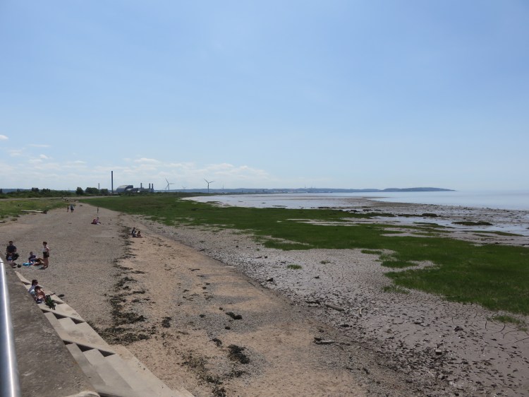
You will be greeted by your first view of the Severn Estuary. The estuary has the second highest tidal range in the world, and therefore every visit to Severn Beach is different. At the time of this visit the tide was low, revealing the famous Severn Estuary mud that makes Severn Beach so ill-suited to traditional seaside pursuits. However, the estuary at low tide has a desolate beauty all of its own.
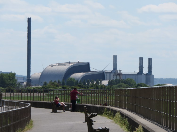
To the left you can see the windmills and power stations of Avonmouth and Royal Portbury Dock. Portishead juts out into the estuary beyond (see Walk Twenty-Six ‘Portbury Wharf and Portishead Marina’ and Walk Twenty-Seven ‘Portishead Cost Path’). The twin islands of Flat Holm and Steep Holm rise out of the water in the far distance.
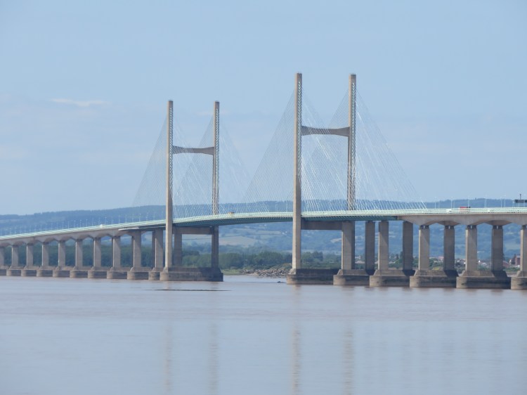
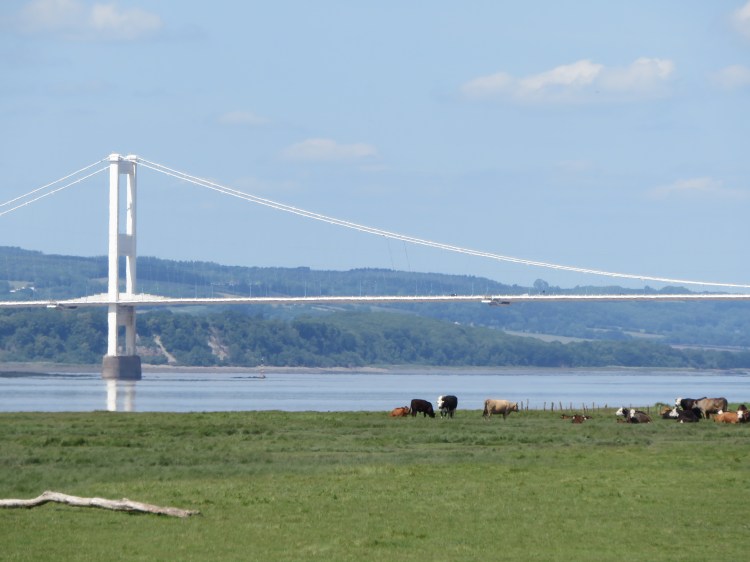
To the right, the view is dominated the striking and elegant modern lines of the Prince of Wales Bridge, which we will be getting much closer to over the course of this walk.
Turn right and head north along the sea wall.
The village doesn’t present its best face to this first section of sea wall, but the area is popular with summer birds. Look out for starlings, house sparrows, house martins and swifts. The views of the estuary don’t let up for a minute.
You will soon reach a slipway where several paths meet and the walk along the sea wall splits onto two levels (3).
Take the upper level for now, and continue walking towards the Prince of Wales Bridge.
Enjoy the view as you walk. Across the water, you can see the hills of Wales and the chimneys and pylons of Newport. Meanwhile, a pleasant park with trees opens out on the other side of the sea wall.

After a while, the park will end as you pass the Salthouse Farm park home estate.
The lower route along the sea wall merges back in here (4). Continue straight on towards the bridge.
Salthouse Farm has a pretty pond in their gardens on the right. On the seaward side you will pass a sunken area containing a radar station.
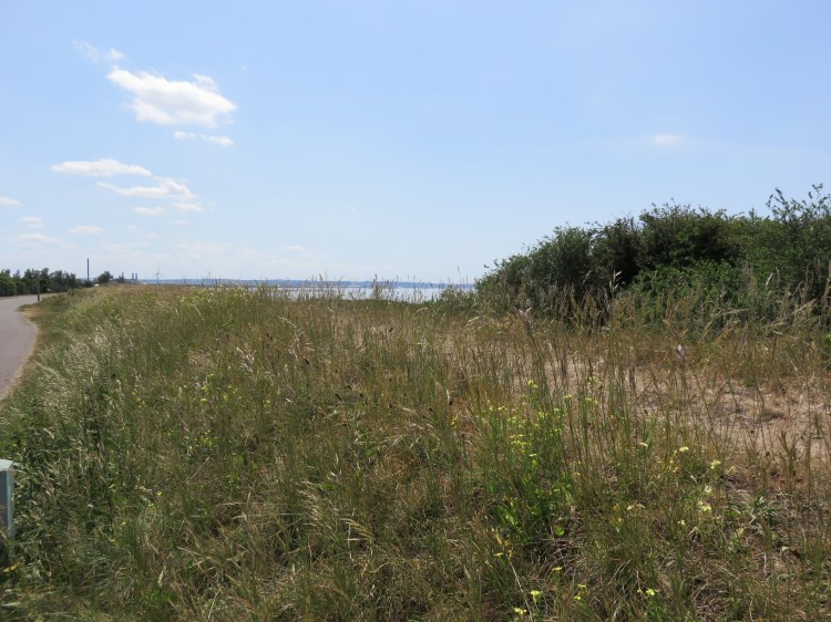
After a while you will pass through a scrubby area with tough coastal vegetation. You are now passing above the Severn Railway Tunnel, which carries main line trains to Cardiff and Swansea. The fenced compound on the right is an emergency access point.
Shortly before the bridge, the path along the sea wall splits into two levels again (5).
Stick to the upper level for now and continue along the sea wall.
You will pass under the imposing concrete structure of the Prince of Wales Bridge. On the landward side is a small row of houses which must once have been a really quiet spot, but nowadays suffer the constant thunder of traffic crossing the Severn on the M4 Motorway.
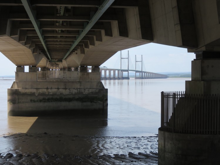
Passing under the bridge, you leave Severn Beach behind you. You are now approaching New Passage, a small hamlet that grew up around the point where the Bristol and South Wales Union Railway used to take passengers across the Severn by ferry.
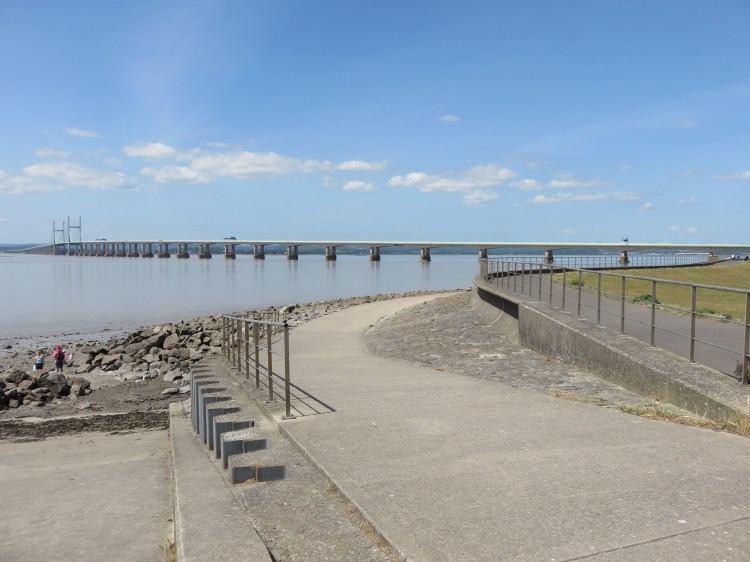
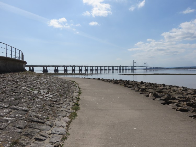
The original Severn Road Bridge now comes into clear view, along with a white villa with many chimneys that punctuates the more rural landscape.
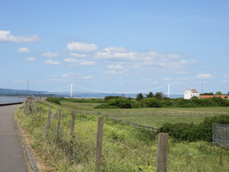
Continue along the sea wall towards the villa.
As you head towards New Passage, enjoy the new views towards the upper reaches of the Severn Estuary and the Forest of Dean. Look out for seabirds on the wild shore to the left.
Next to the villa, the path dips down and you temporarily lose the view. You will resurface at the point where the lower path rejoins the main path (6).
You have arrived at the remains of the Union Railway pier. This is where the trains of the Union Railway transferred passengers to a ferry across the water. A plaque at the end of the pier commemorates this history. The houses on the right have been built across the old track bed.

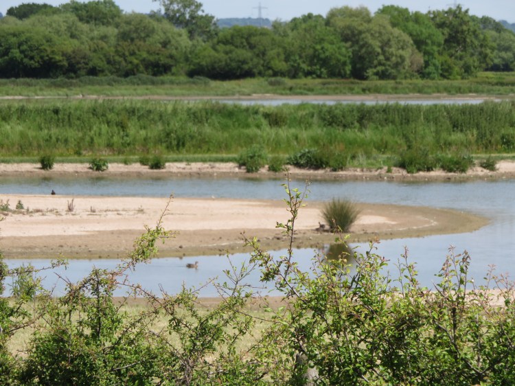
Continuing along the sea wall past the houses and their pretty gardens, you will arrive at a point where the sea wall turns a sharp corner and then terminates. From here, you have a good view of an area of saltmarsh and mudflats that is good for seabirds and wildfowl. Bring a pair of binoculars and, depending on the time of year and the state of the tide, you might see swans, shelduck, Canada geese, lapwing, oystercatchers and other waders such as curlew. You can also explore parts of the stony shore here.
At the end of the sea wall, go straight on through a pedestrian gate (7) onto a gravel track on top of a dyke.
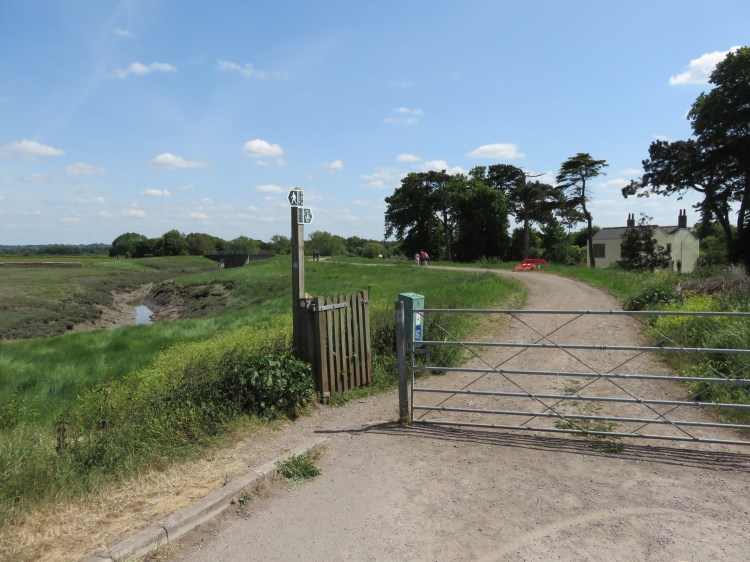
The dyke follows a waterway called The Pill. On the right is a smallholding where you can sometimes spot goats and wild rabbits. After a while you will reach a flood defence called the Chestle Pill Outfall (8).
The final stretch of this walk follows a grassy surface instead of paved path or gravel track. If you’re concerned about your footwear, you may wish to head back from this point.
Otherwise, cross the flood defence and continue through the next pedestrian gate to reach the next stretch of the dyke.
On the right, you can now see the Pilning Wetlands nature reserve, a manmade habitat designed as ecological mitigation for industrial development elsewhere in Severnside. Before the wetlands were built there was a military firing range here, and you will soon pass the first of two old guard posts (9).
If you brought your binoculars, you can see a wide variety of ducks and other wildfowl here, as well as other species of smaller birds that love the brambles and marginal planting.
Follow the grassy dyke past the wetlands until you reach the second guard post (10).
From the far end of the wetland area, you will have your best view yet of the Severn Road Bridge at Aust.
My guided walk ends here, but you can go further if you wish. The path continues along the dyke and then along a quiet road until you reach Old Passage, where the Aust Ferry used to cross the Severn, and from which you can visit the foreshore under the Severn Road Bridge. However, it is a considerable additional hike, and I don’t necessarily recommend attempting it all in one go unless you can get a lift back.
Otherwise, turn back at the second guard post (10) and head back towards Severn Beach.
The path splits into two levels when you return to the sea wall (7), but stick to the upper level at for the moment unless you want to scramble through the railings, as the first section is a dead end.
However, at the Union Railway pier (6), you may wish to take the lower route this time for a different perspective on the estuary and the Prince of Wales Bridge.
When you return to the Salthouse Farm area (4), you may again wish to take the lower route. Watch out for dog mess among the seaweed that has been washed up onto the path.
When you return to the slipway (3), take the path that descends inland through the park. Follow the sharp bend round to the right and then pass through a gate to return to Beach Road and complete Walk Thirty-One.
Coming Up
Only thirty-one walks are currently planned for this project, but I may consider adding more when all of them are complete. Suggestions welcome…
